By Bianca Hall February 13, 2025
Suburb-level satellite mapping compiled exclusively for The Age shows just 4 per cent of Seddon has natural shade – one of the lowest rates of canopy cover in Greater Melbourne.
Satellite imagery produced by Dutch urban advisory group Cobra Groeninzicht, in partnership with RMIT University, shows a thin line neatly dissects Melbourne’s east and west.
From above, the west resembles a patchwork of hot and hotter urban heat islands, with some green patches offering respite (including Keilor, Avondale Heights and Maribyrnong, which have canopy cover of between 27 and 33 per cent).
But the greener suburbs are the outliers in Melbourne’s west. Most suburbs roughly to the west of the Yarra River and Darebin Creek have less than 15 per cent tree cover – even when you take local parks into account.
Contrast this to the leafy east, which from above looks like a patchwork of soft and forest greens. In Park Orchards, for example, canopy covers 90 per cent of the suburb.
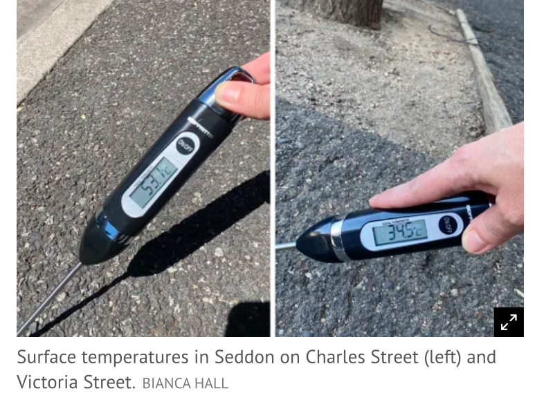
Satellite imagery tells a tale of two cities. Depending on where you live in Melbourne, temperatures can vary by up to 20 degrees. In suburbs like Seddon, surface temperatures can vary by more than 18 degrees within a few hundred metres. The Victorian government has set a long-term target of 30 per cent canopy cover for the public realm, while the NSW government aims to lift canopy cover to 40 per cent by 2036.
Type your suburb in the interactive below and click on the outline to view the canopy cover in your area
All data copyright Cobra Groeninzicht But these targets seem a long way off. RMIT University urban planner Dr Thami Croeser, who helped compile the data for The Age, said a lack of tree cover has social, equity and health effects on residents. “The major growth corridors in Melbourne’s west, north and south-east correspond quite closely to the dark red patches on our map, [while] old, well-established residential areas in the east that have historically stridently opposed development are the places with the best canopy cover,” Croeser said.
“This means that anyone trying to get relatively affordable housing, either with a new apartment or a lower-cost house far from the city, will not have much nature around them, and will swelter in heatwaves.”
Aerial photographs of emerging communities in Melbourne’s west demonstrate how heat islands are being built into growth suburbs. In Manor Lakes, 33 kilometres south-west of Melbourne’s CBD, grasslands are being cleared to make way for new housing.

Most of the houses have been built to the fence lines, with dark grey and black heat-absorbing roofs on the homes and only a handful of trees in the estate. The only relief from the heat is inside air-conditioned houses.
Professor Sebastian Pfautsch, an urban management and planning expert from Western Sydney University, said developers were “moonscaping” natural landscapes to remove waterways, farms and vegetation for new housing developments in the growth corridors of Melbourne and Sydney.
Worse, the ever-increasing sea of black roofs and treeless landscapes was building in heat retention, he said.
“This is 2025, and I find it depressing that we’re still building like that.”
“In the years when you live in your house, you pay thousands of dollars in electricity excess. It’s bizarre. It really is